For most of human history, clouds were the sky’s most dramatic storytellers; bridging heaven and earth and holding omens to predict everything from harvest to childbirth. The Norse believed that Valkyries rode through storm clouds (they were an intense people, those Nordics). Those dark, churning cloudballs that rolled in before a downpour were, apparently, divine warriors on horseback, shepherding the slain toward Valhalla. Ancient Egyptians read clouds as signs of divine presence, while Mesopotamian cultures saw in them something far more unsettling: chaos, the uncontrollable brute force of a universe that didn’t especially care about you. This was the first switch of people being in awe of the clouds to fear of the unknown.


images
- Ancient Egyptian art depicting to the sky as a cosmic ocean (Brown University PhD Victoria Almansa-Villatoro where gods sailed after death.
- Shang dynasty (1600 BC to 1046 BC) bronze ding depicting clouds, Shanghai museum.
- Valkyries from Norse mythology depicted as warriors in the clouds.
If we’re talking about cloud history… the Chinese, these guys started the trend over 4000 years ago, full credit, and brought it back for the 2008 Beijing Olympics as a symbol of harmony. Tracing back to art from the Shang and Eastern Zhou dynasties, the Chinese developed an entire tradition of xiangyun -auspicious clouds; five-colored formations in red, blue, black, gray, and yellow that signal a kingdom at peace; and were so beloved that the motif spread from China to Iran across the Persian empire and eventually to Japan, where they became zuiun through art and myth. Certain clouds were a symbol of good luck, and had central peaceful roles in Taoism (the concept of qi) and Buddhism.
And today? A Mufasa cloud literally dictated Simba’s fate. Carl and Ellie finding the shapes in the opening scene of Up? Damn near broke my heart. Harry Potter and the Goblet of Fire? Girl that SKULL I know that was a sign from beyond and we all listened.
In other words: humans have always looked up at clouds and seen meaning. Which makes a certain kind of sense. Clouds are enormous, ever-changing, and they do determine whether your crops survive the season. Reading them carefully was, for millennia, the difference between being prepared and being caught in a storm. What no one could agree on, until relatively recently, was why clouds looked the way they did. Yet, no matter how much we study them, there is a certain divinity in the formation and movement of clouds. A grace always seen fit for gods. We can’t science it all.

It starts with invisible water
People think Earth is so special because of one thing that’s so not mindblowing that it’s mindblowing – water. That’s all that gives us life. All those fancy alien searching telescopes? Looking for water. 2 H and 1 O. To be fair, water has a lot of cool properties I won’t talk about today. I’m a fake hater. Today we will focus on ONE cool H2O fact: water exists in liquid, solid, and gas, and the atmosphere holds water in all three forms suspended above your head.
The Water Song
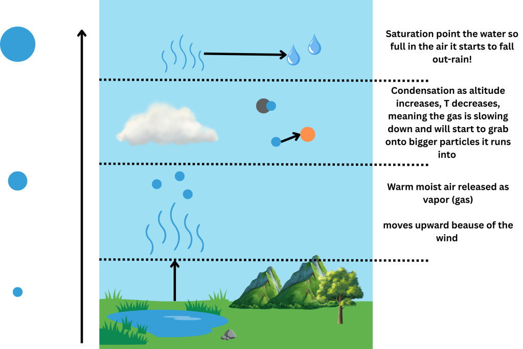
Before there can be a cloud, there has to be water vapor, the invisible gaseous form of water that floats around in air all the time without you noticing it. Air can only hold so much of it, depending on its temperature. And the atmosphere is really in its simplest form broken down by different sections of temperature inversions. The warmer the air, the more water vapor it can contain. But when air cools down, or when enough moisture accumulates, the air reaches what’s called its saturation point: it can’t hold any more. The straw that broke that poor camel’s hump. At that moment, water vapor begins condensing around tiny airborne particles – dust, low volatility clusters, black carbon – forming microscopic liquid droplets. Enough of those droplets together, and you have a visible cloud.

The question of shape, though, is really a question of where this happens, and how the air got there in the first place.
The bubble that becomes a cumulus
Think about the blackest of black tar driveway on a sunny day (a barefoot hell). It absorbs heat more efficiently than the grass surrounding it, making the air above the tar warm up and become less dense. Eventually, like a bubble in a lava lamp, it breaks free and rises. This is called a thermal. This is also why you can see hawks and eagles circling a column of air without flapping their wings – they found an updraft (rising air that could be caused by a thermal) and are surfin round like Crush and Squirt no work all play.
As that bubble of warm air rises, it expands and cools. When it cools enough to hit the saturation point, condensation kicks in, and a small, puffy cumulus cloud pops into existence, with a flat bottom (I’m mature enough not to make a joke about this) marking the condensation level, and a rounded, sheep wool lookin-like top where the warm air is still pushing upward. A cumulus type of cloud is normally what you think of seeing shapes in! Come here darling, let’s comment on the cumulus.
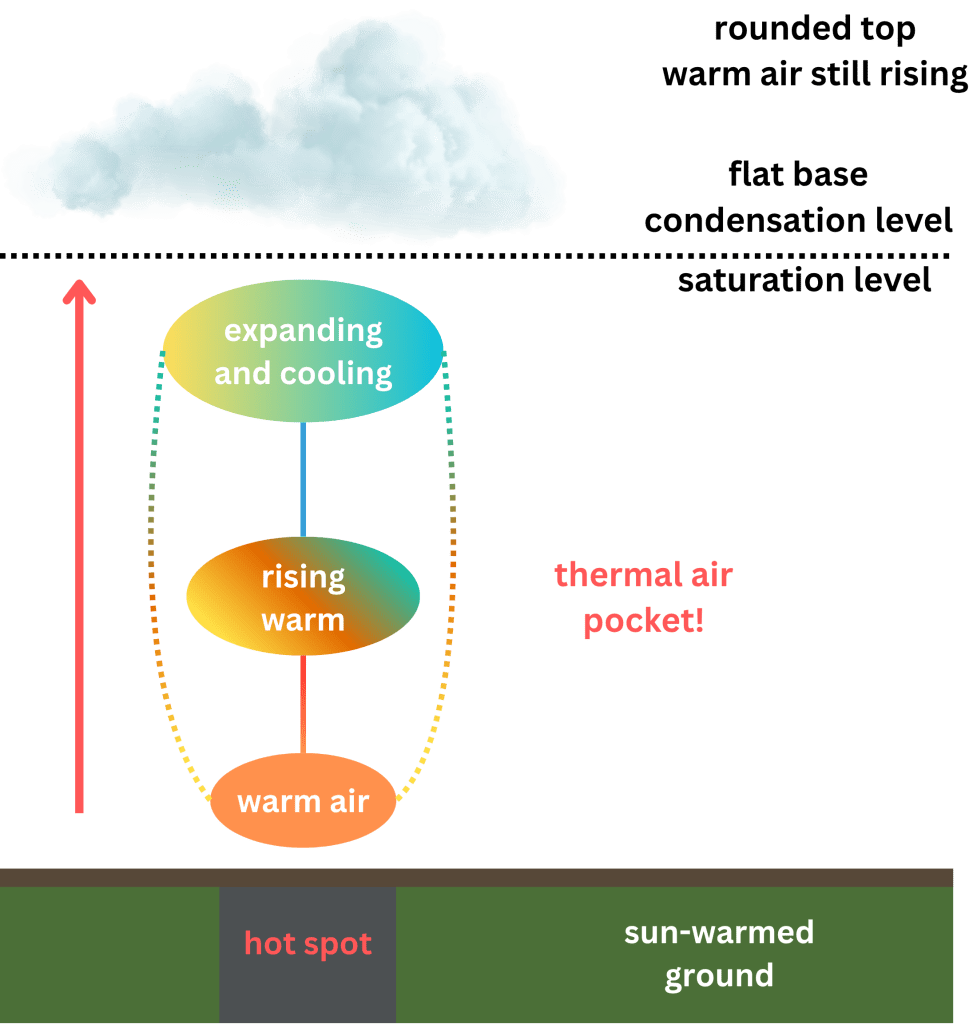
The flat bottom isn’t coincidental (a big hill my PhD advisor will die on). Every cumulus cloud in the same region tends to have its flat base at almost exactly the same altitude, because the condensation level is determined by the temperature of the air mass- and on a calm summer day, the air mass is fairly consistent across a wide area. The clouds end up looking like they were stamped out with a cookie cutter at the same height, which is a little uncanny when you notice it.
Why clouds cluster and why the sky is sometimes completely empty
Clouds don’t distribute themselves randomly across the sky, and there are two main reasons for this. The first is that they’re sisters. Cloud formation is from warm patches of ground, mountain ranges, weather fronts; which are not random. Where there’s uplift, there are clouds. Where there isn’t, there aren’t.
The second reason is that they’re clingy (relatable)- a kind of self-perpetuating feedback. When a cumulus cloud forms, the condensation process releases latent heat, which slightly lowers the air pressure immediately around the cloud. That drop in pressure encourages more surrounding air to rise upward, feeding the existing cloud and encouraging new ones to form nearby. So clouds, in a sense, attract other clouds – which is why on a summer afternoon you often see a growing mob of them bunched in one half of the sky while the other half stays obstinately clear.
The completely clear days have their own explanation: high pressure. Under a high-pressure system, air is slowly sinking rather than rising. Sinking air compresses and warms, which actually reduces its tendency to condense – the opposite of what you need to make a cloud. There are no mechanisms for cloud formation, and so there are no clouds. It’s not that the sky is hiding them; they simply never get built.

The role of wind and pressure in shaping what you see
Wind doesn’t just move clouds around, it determines their shape too. Altostratus, the flat grey sheet that covers the whole sky before a slow rain, forms when a large air mass is lifted gently and uniformly over a wide area. Cirrus clouds, the wispy high-altitude streaks that look like brushstrokes, form in extremely cold air at high altitudes where ice crystals, rather than water droplets, are the medium, and strong upper-level winds shear them into those characteristic commas and filaments.
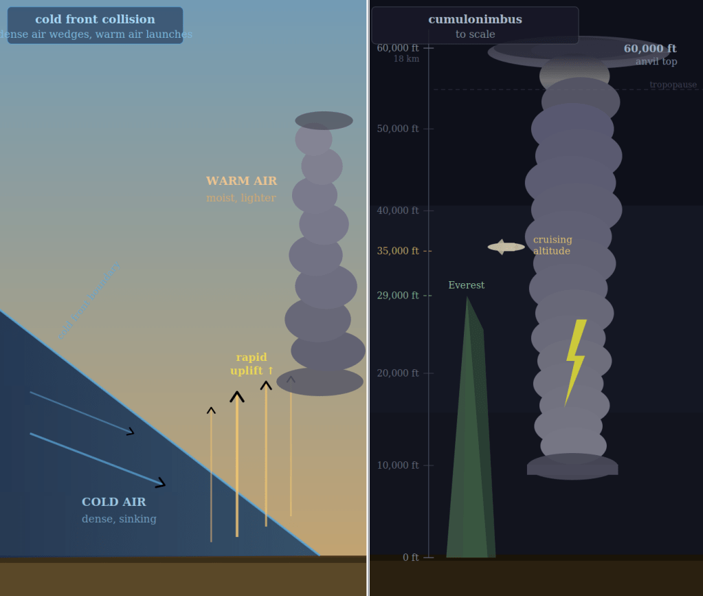
Low-pressure systems produce some of the most dramatic cloud formations precisely because they’re doing something turbulent: when a cold front slams into a warm air mass, the cold, denser air wedges underneath and forces all the warm air rapidly upward. That sudden vertical lift, combined with the moisture in the warm air, can build cumulonimbus clouds; the towering thunderheads that can reach 60,000 feet with startling speed. The Valkyries, one imagines, would have been having the time of their LIVES.
Reading the sky
What’s remarkable is that ancient cloud watchers weren’t entirely wrong. They noticed that certain cloud shapes reliably preceded certain weather – even if they attributed them to divine displeasure rather than pressure gradients. The shape of a cloud really is a message, just from physics rather than the gods. A ring of high cirrus clouds often means a weather system is approaching from the west. An anvil-shaped cumulonimbus means a thunderstorm is here, right now. A flat, blue sky under high pressure means you probably don’t need your umbrella. The sky has always been speaking. It just took us a while to learn the language.
Citations
Abercromby, Ralph. “Cloud-Land in Folk-Lore and in Science.” JSTOR. (Journal record of the 1887 lecture.)
National Weather Service (NOAA). “Cloud Development.” ZHU Training Page.
NOAA National Environmental Satellite, Data, and Information Service. “Types of Clouds.”
“Why Do Clouds Always Appear in Certain Parts of the Sky?” Scientific American.
NOAA JetStream. “Origin of Wind.”
CULTURAL HISTORY
“Auspicious Clouds.” Long Museum West Bund, Shanghai.
“Unveiling the Layered Mysteries of Mythical Cloud Symbols.” Platinum Image Hotel Blog.
Hewsen, Robert H. Review pertaining to Anania Shirakatsi’s cosmological description of the Earth. Journal for the History of Astronomy. University of Chicago Press.
A side piece about the Beijing 2008 opening ceremony and how clouds played a role:
Liang, Yuying. “The Production of Space and Representation of Culture: A Case Study of the Opening Ceremony of Beijing Olympics.” Journal of Comparative Literature and Aesthetics, vol. 44, no. 1, Spring 2021, pp. 128–143. Jawaharlal Nehru University, New Delhi.


Leave a comment